MapInfo Pro
A complete, desktop mapping solution for the geographic information system (GIS) analyst to visualize, analyze, edit, interpret, and output data — revealing relationships, patterns, and trends.
Confidently explore, model, and act
Location data adds both insight and complexity to corporate decision making. Mistakes are too expensive for a trial-and-error approach to mapping. If you’ve opened a new shopping mall, you can’t relocate it once you realize your location intelligence was bad and you’re not drawing the crowds you need.
MapInfo Pro GIS software employs geospatial analytics and location intelligence to help you create insightful models of location-centric scenarios. Use these models to simulate different outcomes — then act with confidence. Use MapInfo Pro to:
Benefits
Complete solution
An all-in-one solution that manages, analyzes, and visualizes data for mapping and map publishing
Custom applications
Solve your specific business needs with customized applications available in the MapInfo Marketplace
Scalable analytics
MapInfo Pro supports teams of all sizes, delivering tools for use across the entire organization
User-centric collaboration
Professional peer communities provide ideas, tips, and tricks

Explore
Better understand a location by gathering information about its key features and how they interact. Visualize data through map symbols, themes, and labels. You can even overlay multiple datasets on a single map to distinguish patterns that would not otherwise be visible.

Model
Integrate your corporate data with maps and demographics. Combine this information with our powerful spatial querying and modeling tools. Run different scenarios for an accurate, up-to-date representation of a location’s possibilities.

Act
Build models that are easily understood by non-technologists. Enable corporate decision makers to fully understand the attributes and drawbacks of each site, in each scenario. Help them take the type of action that propels business.
 Learn how to supercharge telecom service upgrades with MapInfo Pro
 Learn how to supercharge telecom service upgrades with MapInfo Pro
Bring a new dimension to your spatial data
We live in a 3D world, so visualizing three-dimensional spatial data provides a more comprehensive and realistic representation of terrain, buildings, and objects.
Some applications – like disaster management, coastal modeling, and urban planning – will rely entirely on your ability to create realistic digital representations. And 3D visualizations offer a more intuitive and immersive view of geospatial information, making it more accessible for non-GIS teams.
With MapInfo Pro, you can easily visualize your 3D data using OpenGL rendering without additional tools or extensions. Quickly display data in 2D and 3D simultaneously to reveal patterns and relationships not seen in traditional visualization, then share your findings with broader teams for greater impact.
Unlock the next dimension in spatial analytics
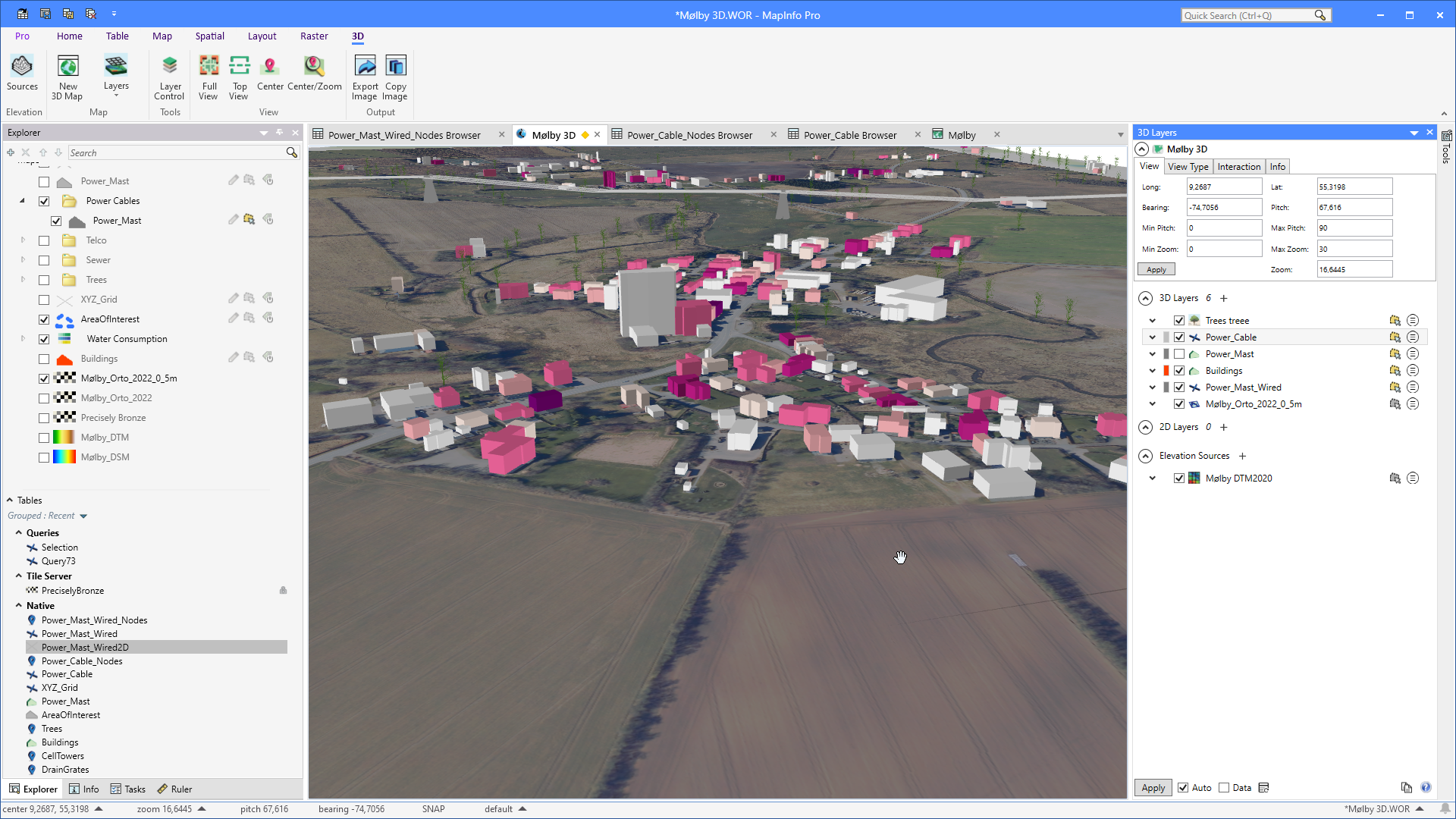
Viewing your data in 3D brings a new perspective
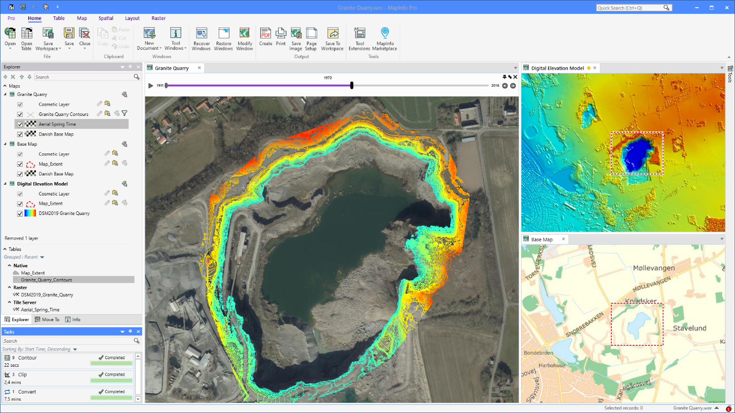
Time series analysis of granite quarry extraction
Extract information from raster data
Creating optimum insights from large spatial files can be a significant challenge. Use our patented Multi-Resolution Raster (MRR) data format for powerful spatial processing and map rendering. Identify, quantify, and visualize spatial patterns in raster datasets of practically unlimited size. Or use our Multi-Resolution Virtual Raster (MVR) to virtually merge, reproject, and resample raster grid data on-the-fly, without writing out new grid files to disk.
“With the network changing and developing rapidly, up to-date network information is vital to guarantee quality and stability to our existing customers and prospects.”
Arian de Korte, Operations DirectorCustomize MapInfo Pro to meet your needs
MapInfo Pro users can access custom features and functionality via the MapInfo Marketplace, a collaborative space where users can download and share plugins for the software.
MapInfo Marketplace plugins include:
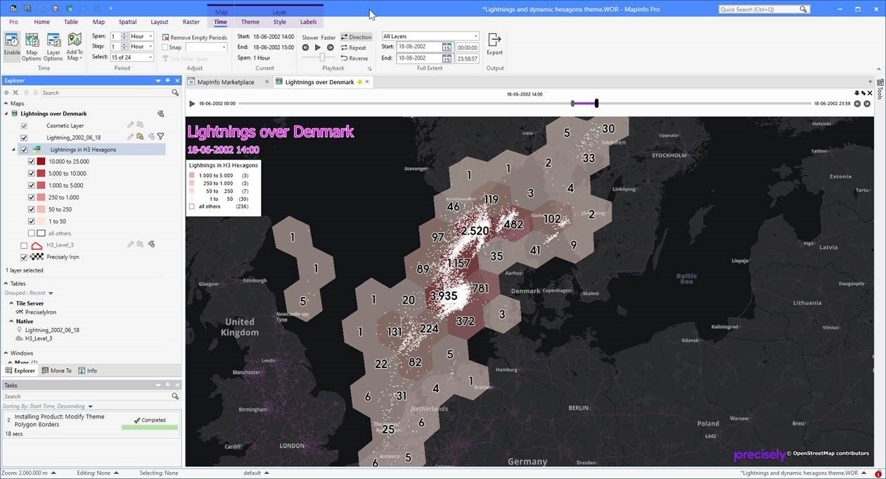
Weather analysis using time series and hexagon theme
MapInfo Pro Drone
Commission project-specific datafrom a global network of more than 10,000 certified drone operators.
Python and MapBasic Support
Increase productivity by building, running, and reusing customized applications. MapInfo Pro offers robust support for MapBasic and Python scripting languages.
Geocode and Drivetime
Take advantage of best-in-class geocode and drivetime analysis directly within the MapInfo Pro interface.
MapInfo Pro Viewer
Drive collaboration within your enterprise with the free MapInfo Pro Viewer. It allows line of business users to open any MapInfo workspace. Open tables in read-only mode and perform basic map operations such as pan, zoom, or reordering layers.
The GIS you trust — now a subscription service
Maintain your GIS edge with a MapInfo Pro subscription. You’ll enjoy a reduced price while automatically receiving:
- 1-3 year subscription options
- Continued support for web-based data services, including Bing imagery
- Access to the latest MapInfo Pro software updates and upgrades
- Expert support via phone, chat, and email
“As a MapInfo Pro user for three decades, it has been my sole GIS mapping tool. The interface is easy to use and very powerful. Reducing file sizes with the Multi-Resolution Raster (MRR) format has dramatically helped to open and display large datasets. For those projects where you need to see data changes over time, the time series feature is impressive.”